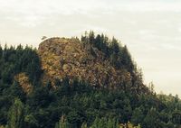
yədwasta
Revision as of 02:43, 7 February 2017 by Ben Barrett (talk | contribs)
| Location: | Just southeast of the roundabout where highways 9 and 538 (College Way) meet, near Nookachamps Creek. Visible from Knapp Road. | |
| Google Maps: | 48°25′48.996″N 122°15′58.672″W |
Lushootseed noun
pronunciation: yəd was ta
word analysis: yədwas ("heart") + ta (emphatic particle)
Number of times this entry has been verified against the sources, including at the time of creation: 1
In general, an entry with a higher number of verifications and sources may be considered more reliable.
sources
- 1999, Jay Miller, Lushootseed Culture and the Shamanic Odyssey, ISBN 0-803-23200-4, University of Nebraska Press, p. 54
- 1972, Chief Martin J Sampson, Indians of Skagit County, Skagit County Historical Series No. 2, Mount Vernon, Washington, p. 19
- 1994, Dawn Bates, Thom Hess and Vi Hilbert, Lushootseed Dictionary, ISBN 0-295-97323-4, University of Washington Press, pp. 215, 276
